SA - South
- Ken Fredric
- Mar 5
- 42 min read

Updated: Apr 6
Day 26 - Port Augusta - Clements Conservation Park SA, 07 March, 2026
This was our first day of exploring the southern region of South Australia.
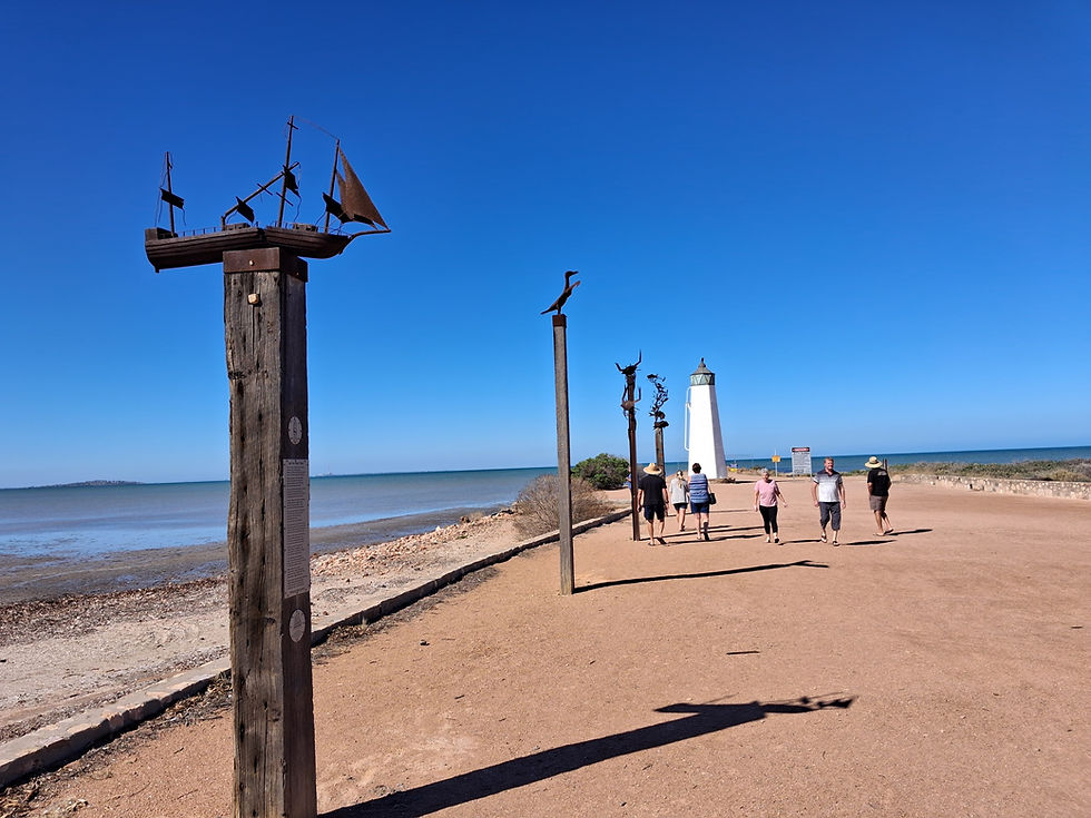
Leaving Port Augusta we drove to the small town of Port Germein. The town was once the largest grain export port in Australia but now not much goes on there. At the entrance to the jetty area there were a few information boards detailing the history of the town, and particularly the port area which boasts a jetty that is 1.6 km long. Unfortunately the jetty was damaged by high tides in 2025, so we couldn't walk out there.

For a change of pace and scenery we then drove the Port Germein Gorge Tour, through some nice but unspectacular rock formations.
Our next destination was the small country town of Wirrabara, where our first stop was at their silo art installation, which was one of the better examples we've seen.
About 10 km out of town we visited the King Tree, a huge River Red Gum tree that is thought to be around 400 year's old.

Then, back in town we went to the pub for a nice lunch, our first lunch out for some time. While waiting for our lunch to come out the hotel owner brought a wildlife rescue Joey out to see us and Meg had a cuddle.
After lunch we intended to check out their arboretum, but we couldn't find the entrance, so instead got back on the road and headed to Port Pirie to see a few of the town's highlights.
Our last drive of the day was to our free camp for the night at Clements Conservation Reserve, about 40 km out of Port Pirie.
Unfortunately we were forced to stay inside because of the rabid flies, which was disappointing because it was over 30 degrees.
Day 27 - Clements Conservation Park - Moonta SA, 08 March, 2026

Continuing our journey south today down the west side of the Yorke Peninsula, our first stop was at Port Broughton to make use of their dump point and to check out the foreshore/jetty area. There was a cool breeze blowing so we didn't linger too long there or walk out the jetty.
Carrying on, but going inland a little our next stop was at Bute to see their impressive silo art, some metal art and old buildings.
Then, heading back out towards the coast, we stopped in Kadina, the largest town on the Yorke Peninsula. After parking up on a side street we went for a walk around the central area to look at some of their wall art, most of which wasn't that impressive.

Next up, back out on the coast, we called into Wallaroo and, once again, went to the foreshore area where there was a very long jetty and grain-loading conveyors running from the adjacent grain storage facility.
With nothing else we wanted to see or do there we carried on Moonta, where we pulled into the very busy RV park and found a site for the night.
After setting up and having lunch we went for a walk into the town, which was buzzing, it being market day, and all the cafes, restaurants and shops were busy. We wandered around the markets and some of the streets, admiring many old buildings and houses, before popping into the pub for a cold beer.
That was enough touristing for one day.
Day 28 - Moonta - Port Victoria SA, 09 March, 2026

Another day, another jetty! Three in fact!
After breaking camp this morning our first stop was back at Queen's Park to look at some statues that we couldn't see the day before because of the markets.
There was a Wombat statue that memorialised the finding of copper in the area in the mid 1800s, a piano statue that memorialised a local who was a prolific musician, a water feature and a statue of Sir Richard Williams, the founder of the RAAF.
Next up was a visit to Moonta Bay, our first jetty stop of the day. The morning was beautiful, with only a gently breeze, so we walked most of the way out the jetty, past many fisher people, perhaps more than usual because of the public holiday.

A little further around the coast we stopped at Port Hughes briefly to compare their jetty to all the others we'd seen, before driving back into Moonta then out of town to the old mine site and museum.
Unfortunately the national trust had closed the museum, which was housed in the beautiful old building that was the Moonta Mines School, until Easter.
We wandered around the site reading information boards and checking out old buildings and machinery before driving around some other sites like an old engine house and chimney, and a miner's cottage that had a beautiful garden behind the cottage. We learned that the Moonta copper mine was the first in Australia to produce a million pounds worth of copper.

All done in Moonta, it was time to get back on the road towards Maitland, but diverted off onto an unsealed road to Balgowan to check out some potential campsites for the night. The potential was minimal when we got there because the sites were up on cliffs looking out over the ocean - spectacular views but the wind would be a problem.
Apart from some beautiful trees on the way into Maitland, there was nothing else we wanted to stop and see, except the old buildings we drove past, so we continued on to Port Victoria, where we planned to stay the night.
On the way into town we checked out the showgrounds for a camping spot, but found that, because of the town's 150th celebrations, the showground oval was closed to RVs and the camping area had been moved next door to a high windy site beside the bowling club. The only other option was the campground, which we thought was too expensive, so opted for the cheaper $10 site at the bowling club.

In town we parked up...........by the jetty and had lunch, then went for a wander around the jetty area reading about the geological trail that runs along the coast showing varying rock formations created by a volcano millions of years ago.
After paying for our night's accommodation at the store beside the jetty we drove around the streets for a bit looking at some of the old buildings, then went back to the showgrounds, where the notice that was there earlier saying no RVs on the oval until the next day had been removed.
Great we thought, and set up on the grassy oval not too far from the toilet block.
But then, after an hour or so, a man came and said we couldn't park there because the sprinklers were going to be turned on soon, which meant we had to move to a dusty area a
long way from the toilets.
Day 29 - Port Victoria - Gleeson's Landing SA, 10 March, 2026

Continuing on our southward journey down the west side of the Yorke Peninsula, Minlaton was the first port of call for the day, but it's not actually a port.
The town's main claim to fame is that it was the hometown of Harry Butler, a WW1 pilot who came home from the war with two planes and used them around the area for joy rides, stunts and for the mail run. He unfortunately died at the young age of 34 after suffering injuries from a plane crash three years earlier. His Avro plane had been restored and was on display also.

Because Minlaton was the last reasonable sized town we'd be passing through for a while we took the opportunity to garb a few things from the supermarket before leaving town.
Driving back out to the coast we diverted off to Point Turton to see a cave on an isolated beach. The cave wasn't that impressive but the sheltered bay the cave was located in was really nice.
On our way out of Point Turton we encountered a closed road that meant we had to turn around and go back through town to get onto another road to our next destination, Corny Point.

After stopping briefly in the small township to read some information boards we carried on out to the Corny Point lighthouse. Once we'd taken the obligatory photos we parked up in this beautiful location, facing the ocean, for lunch.
Not far along the road from the lighthouse we pulled into the Berry Beach North carpark to take some more coastline photos and were lucky enough to see a pod of three dolphins cruising past in shallowish water, and one even enjoying a surf not far from some human surfers.

The last drive for the day was to Gleesons Landing, an unknown quantity, but which turned out to be one of the nicest camping spots we've had, right beside the ocean in a large protected bay, and with the bonus of only having a gentle breeze. The camping area is huge so we were able to find a great site well away from anybody else.
As we were setting up an Osprey flew in behind us and sat on the rocks for a while before taking off. It came back again a little later to the same spot and would start making noises if we got too close to it.
Day 30 - Gleeson's Landing - Innes NP SA, 11 March, 2026

Today was going to be spent exploring the southern tip of the Yorke Peninsula, in the Dhilba Guuranda - Innes National Park.
Our sleep was disturbed somewhat overnight as a howling gale blew through our idyllic campsite, which meant having to get up to close windows, and to retrieve the Starlink from the bonnet for fear it would blow away.
The first stop for the day was at Marion Bay for a quick look around and to take some photos from their lookout. We didn't linger though because of the strong and cold wind that was still blowing and the cloud cover.
The sun did come out a little while later but the wind persisted through the day.

It was a short drive from there to the Innes NP entry where we stopped at the visitor centre for some information on what we would be looking at today. Unfortunately the park staff were having a meeting and the centre was closed, so we had to make do with a map of the park, including all the points of interest, that was available outside the door.
When we pulled up there we were surprised to see another Explorer in the carpark, which belonged to Michael and Annika, #636 TV, from Brisbane. We played tag with them all day, meeting each other at most of the attractions.

The first attraction we stopped at was the Spencer Gulf lookout, where we had views of the rugged coastline, the ocean, and across to the Cape Spencer lighthouse.
We then drove past what would be our camp for the next two nights at the Cable Bay campground, and onto the lighthouse. Once again the views were impressive being able to see in both directions along the cliffs and beaches either side of the lighthouse. We read the information boards that documented the ships that had come to grief in the area.

Next up was Ethel Beach where parts of the wreckage of two ships were scattered around the beach below the lookout.
Moving further around to the west coast of the NP we came to West Cape, which had another lighthouse. There was also a 1 km loop walk up to the lighthouse and around the wind-swept cliffs that we chose to do, which gave us great views of the next two bays along the coast.
By then it was lunch time, so we drove a little bit further to Pondalowie Beach to eat, then did a short walk out to the beach that looked over Pondalowie Bay.

For our last walk of the day we stopped at the Pondalowie Surf Break carpark and set out on the 1.2 km walk, much of which was over a boardwalk that went all the way down to the beach. However, the last 50 or so metres of the boardwalk was closed because of recent storm damage, so we couldn't get to the beach without climbing over sand dunes, and we weren't inclined to do that.
The last drive for the day was to the Cable Bay campground, where we got ourselves organised for a two-night stay. We had been bemoaning the lack of wildlife around the park, so were pleased to see a flock of Emus not far from where we were camping.
The wind was still strong and cool, which kept us inside for the afternoon.
Day 31 - Innes NP SA, 12 March, 2026

Today was to be our first 'down day' of this trip, with very little planned.
The one thing we did want to do though was to visit the nearby historic village of Inneston.
Inneston was founded in the 1880s and was originally a farming community until the discovery of Gypsum in 1913. Mining ceased sometime around 2003.
After our morning ritual we donned shoes, and jackets to ward off the cold wind, and set out on the 2 km walk through open bush country to Inneston.

We were just near the town area when a family of dad and four young Emus wandered down the road towards us. We stepped off to the side of the road and the Emus walked past us slowly, watching us warily.
While the old township is largely old buildings in varying states of decay, there are still many buildings in good condition that are used as holiday accommodation, including the two grand buildings up the hill above Inneston that were once occupied by the chief engineer, and the other by the Innes family that the town was named after.

We walked around for a while checking out the old buildings, like the bakery, which didn't have doors, windows or a roof anymore, but still had the original oven and a fireplace.
Having seen enough we walked back to base camp and went over to the nearby beach. Sadly the beach wasn't very inviting and we couldn't easily actually get down to the sand, so we gave up on that idea.
We'd been putting off some chores for a while, like checking that our spare tyre was still in good condition, that we could wind it down easily if required, and re-familiarising ourselves with the process. We also checked that our hidden spare key to the cab was attached and that we could access it easily, which required some dusting off of red dirt and some graphite powder to loosen things up.
With the chores and lunch out of the way, there was nothing more to do than chill for the rest of the day, inside unfortunately because of the cool wind.
Day 32 - Innes NP - Yorketown SA, 13 March, 2026

The cool wind blowing the day before turned into a howling gale overnight that had us rocking, but not rocking us to sleep! It was a very unsettled night.
We weren't planning to drive very far today so we went into potter mode on the quiet roads.
Driving back into Marion Bay we turned off onto the South Coast road where there some potential sights to see.
The first point of interest we stopped at was the Kangaroo Island lookout, but the view of the island wasn't great being so far away, and the strong wind was still persisting so it was a short stop.
Next up was some impressive water tank art just outside Port Moorowrie depicting a few local historical scenes.
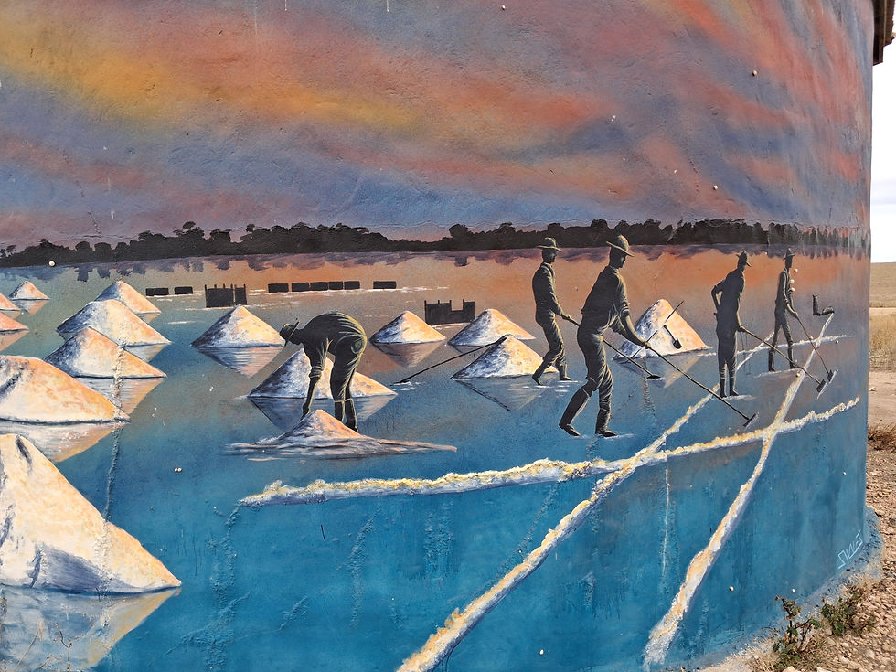
Further along some rough unsealed roads there was more water tank, this time depicting some wildlife and historical scenes of farming and harvesting salt from the many local salt lakes.
We stopped for some pictures of one of the salt lakes, which was bright pink, on the way into Yorketown.
Driving the last few days, every time we got out of the vehicle and left the motor running we thought we could hear more noise than usual.

With that in mind, when we arrived in Yorketown we went to a motor repair business to get it looked at. They thought that one of the V-belt tensioners may be wearing and causing the noise. We weren't in a position to do anymore about it at that time, because we couldn't afford to lose our house for any length of time, so we took the advice on board and decided to keep on going and hope it doesn't get any worse.
After a little shopping expedition we drove to the caravan park and setup on a powered site (because that's all they offered) for the night, looking forward to a nice hot shower for the first time in days.
Day 33 - Yorketown - Port Julia SA, 14 March, 2026

For some strange reason I woke up with vertigo-like symptoms this morning, causing nausea any time I moved. That was a cue for Meg to be the driver for the day.
We didn't plan to drive very far today, but there was quite a lot to see on the way.
After leaving the campground we stopped first at Yorketown's water tower to check out the artworks, before heading out of town to Edithburgh. This was part of an art trail, with most towns having some form of water tower/tank or wall art.

We'd researched the price of diesel in the towns we would be passing through, to try and find something reasonably priced amidst the fuel crisis being caused by the prized wanker who is the current president of the USA. Edithburgh had one station selling diesel for $2.03, so that's where we headed first to top up our tank. However, when we got there, there were signs on the pumps saying that they were out of fuel. We found fuel later on in Stansbury but had to pay $2.68 per litre for the privilege.
Leaving Edithburgh we had a look at their water tank art and the metal horse sculpture, before continuing north up the east coast of the Yorke Peninsula to Coobowie.

Coobowie had some more water tank art and animal sculptures that we stopped to look at, then carried on to Wool Bay for more water tank and wall art. The wall art here depicting the carting of wool by horse and cart had won an award for best wall art in 2023.
Stansbury was our next stop, to fill up with diesel and take some pics of their water tower art.
Our last stop for the day was the small coastal town of Port Julia, where we drove up to the lookout for a view over the town and out to sea, before going to the bush camp on the edge of town for the night.
Day 34 - Port Julia - Blyth SA, 15 March, 2026

This was to be our last day exploring the Yorke Peninsula before heading north to the Clare Valley.
My vertigo seemed to have improved a little, so I resumed the role of driver for the day.
Our initial plan was to drive the short distance to Ardrossan and stay there the night so I could go to the medical centre, if necessary, the following day on the Monday. However, because my symptoms had waned somewhat that plan changed as the day went on.

It was only about 20 km to Ardrossan and our first stop was not far out of town at the site of a mass Sperm Whale stranding in 2014. Seven whales perished that day.
Just a little bit further along the road was the town lookout where we had views of a large open-cut mine site behind us, the Viterra grain loading facility, the town and the old jetty.
In town we visited a waterfront park where there was a memorial to the men who had invented the stump jump plough, which was patented by the Smith brothers in 1878.

Then, because we'd only been doing small shops for the last few weeks we hit the supermarket and stocked up on everything so we wouldn't have to do a big shop in Adelaide the following week.
With that done we checked out some wall art, a metal horse sculpture and a display of old ploughs.
Our last drive for the day was to the small town of Blyth, lunching at a roadside rest area on the way, to camp at the local showground that was free, but still provided toilets and showers.
The temperature had soared up to 33 degrees while we were driving, so we ideally wanted to sit outside to catch some breeze, but the flies were very challenging to say the least.
Day 35 - Blyth - Auburn SA, 16 March, 2026

While we didn't know where we would end for the day today, we did know that the highlight for the day was going to be a wine tasting and lunch at one of the many wineries in Clare.
We were in no hurry to leave camp because the drive from Blyth to Clare was only around 20 km, and the winery we'd chosen didn't serve lunch until midday.
In Clare our first port of call was the Gleeson Wetlands, as much for the name as for something to do to kill time until lunchtime.

There was light rain falling so we only checked out the bird hide and walked briefly around some of the small lakes.
There were some metal sculptures of a farmer and his dog herding sheep not far away, so that was our next stop to take some photos.
It was still way too early for lunch so we decided to drive out to the nearby town of Farrell Flat to look at their silo art, which depicted the heyday of the town when steam locomotives stopped at the station there.

To use up some more time we parked up there for a cuppa, before driving back to Clare via Mintaro.
On the outskirts of Clare we called into the information centre to use up even more time, and spent some time looking at the local wares they were selling, including a bag that Meg bought to use as a bottle bag when out walking, as we'd left ours at home when packing.
Before going to the winery we topped up with diesel to make sure we would have enough fuel to make it to Bendigo, if the smelly brown stuff hit the fan with the current political situation.
With nothing else to do in Clare we drove to the Mr Mick Winery for lunch. It wasn't quite midday yet, so we chose to do a wine tasting first, choosing a variety of white and red wines, and a rosé.

With our favourite wines chosen we went to the restaurant, ordered a couple of those wines and our lunch, which consisted of three smaller dishes and one larger dish, of our choosing.
The food was absolutely amazing, full of flavour and most of it produced inhouse and from local ingredients. By the time we got to the end of the tapas-like meal we were completely stuffed.
We enjoyed some of the wines so much, one of the whites, the rosé, and one of the reds, that we bought some of each on the way out.
Then it was a short drive to the town of Auburn where we checked into an unpowered site for two nights.
Unfortunately the light rain had become a bit heavier on our drive to Auburn, so we stayed inside for the afternoon.
Day 36 - Auburn SA, 17 March, 2026
Today was a planned down day, using up some time before we could go to our booked campsite in Adelaide in a few days time.
The day started off raining, then that eventually stopped but it was overcast and cool for the rest of the day.
We took the opportunity to do a load of washing and to reinflate the tyres that we'd lowered when heading into the Flinders Ranges, but apart from that chilled for the day.
Day 37 - Auburn - Williamstown SA, 18 March, 2026

Our original intention today was only to do a short drive to Gawler and stay in their free RV camping area for the next two nights before going to Adelaide.
One of our gas bottles had emptied a few days earlier, so our first port of call was at Saddleworth to have it filled up. However, when we got there, they were really busy and wanted us to leave it with them for a while.
That prompted a drive out to the small town of Marrabel to check out their bronze horse statue of Curio, a notoriously feisty rodeo horse that went unridden in rodeos for eight years.

Back in Saddleworth we picked up the now full gas bottle and continued on our journey towards Gawler.
We thought the town of Riverton we were passing through looked interesting, so we stopped to wander around looking at the museum area, which was closed, and some of the old buildings.
Arriving in Gawler just before lunch we went straight to the RV park and chose one of the sites that were rapidly filling up. However, we didn't like the feel of it and decided to carry on into the Para Wirra conservation park for a couple of nights.

Unfortunately, along the way, we discovered that the camping area was closed on Wednesdays for pest control. That led to us parking up in a car park, having lunch and looking at other options.
The next best and nearest option was the caravan park in Williamstown, about 20 km away, so that was where we headed to.
After initially paying for and setting up on an unpowered site, we realised that our power wasn't going to recover enough from the 50% it had started the day at, so we had to go and cough up some more money to plug into the 240V for the night.
Day 38 - Williamstown - Para Wirra Conservation Park SA, 19 March, 2026

We had another leisurely start to the day today, with less than 10 km to drive back to the Para Wirra Conservation Park where we wanted to stay yesterday. Our only stop was for a loaf of bread from a bakery in Williamstown.
Once we were setup in our assigned campsite we set out to do some of the walks around the park.
The first walk was the short Pink Gum walk that took us around the campsite on an easy and not particularly interesting track.
Wanting some pamphlets showing all the walks in the park, we then walked to the ranger station, only to find it closed and with no maps outside the building.

One of the nearby walks was down to a lake, about 1.5 km away, so we set out to do that. It was an easy walk through fairly thick bush to the lake and, once there, we had a rest before setting out on the return journey back to the campsite, which was a bit over 2 km away.
Overall, we were pleased that we'd covered over 5 km for the morning by the time we got back to home base.
After lunch we did some blogging and planning for the next few days in Adelaide, so that we could maximise our time there.
We finally had a day that was nice enough to sit outside, so that's what we did for the afternoon.
Day 39 - Para Wirra Conservation Park - Adelaide SA, 20 March, 2026

With another short driving day in front of us, it was a leisurely start to the day.
Instead of driving directly into Adelaide we wanted to check out Beerenbergs in the Adelaide Hills, a family-owned business that primarily produces jams and sauces, and which has been operating since 1839.
That first drive for the day took us through the very picturesque Adelaide Hills, over narrow, winding roads and into Hahndorf, a beautiful town with narrow tree-lined streets that reminded me a bit of Arrowtown in New Zealand.

We found a park in the main street and had a short walk along the main street, before carrying on to the outskirts of town where Beerenbergs were located.
We were going to have some morning tea in their cafe, but couldn't find anything we really wanted to eat, and we had a lunch out planned, so we just browsed through the shop at their extensive range of products.
Plucking up some courage we then drove towards Adelaide's city traffic, but initially skirted the city and went first to the seaside suburb of Glenelg.

We had a pleasant walk alongside the marina, where there was an installation of Reg Griggs' diving bell, the gentleman who founded Arkaroola, and who we'd heard all about from his son on the ridgetop tour.
Having worked up an appetite we walked to the marina restaurant precinct, where we enjoyed a very nice, if a little expensive, lunch and drinks at Sammys on the Marina.
Next up was a drive, mostly along the waterfront, to Port Adelaide, where we parked up, visited the information centre, then walked around the streets marvelling at the old buildings and checking out the many murals on the building walls.

By then it was getting close to check-in time at the campground, so we suffered through the Friday afternoon traffic to the Adelaide Showgrounds campground and got setup for a two-night stay.
It was a beautiful sunny afternoon and we enjoyed sitting outside making the most of the nice weather that we hadn't seen much of for a while.
Day 40 - Adelaide SA, 21 March, 2026

Today was all about exploring as much of Adelaide as we could fit in, in a day.
We didn't set out too early however, so that we didn't have to pay extra for public transport in peak hour time.
Luckily there was a bus stop right outside the campground, but we had to walk about 500 metres around fenced areas to get to it. The bus took us into the centre of the city, not too far from the central market, which was our first destination for the day.
The market is huge and jam-packed with most things culinary and also with people. There was every type of food you could possibly want - it would be a great place to do a weekly shop.

Not actually needing anything foodwise, we jumped back on the bus and went to the Rundle Mall, which was very reminiscent of the Queen Street mall in Brisbane, full of mostly expensive shops.
From there we walked to the Migration Museum, which housed a wonderful, and sad, collection of the stories of people who had migrated to Australia since the early 1800s. There were some harrowing stories telling of the treatment some children suffered at the hands of people who ran children's homes, but many other stories of people who had flourished after migrating here.

We then wandered back up to the main street and caught a free tram to the Botanic Gardens where the first point of interest was a cafe for lunch, which took us past some beautiful huge trees, odd plants and colourful flowers. With lunch out of the way we spent some time in the Museum of Economic Botany where they had displays containing thousands of plant species with information on where each came from and how humans have used them over time.
That was all we wanted to see of Adelaide so we caught another bus back to the campground and rested for the afternoon.
Day 41 - Adelaide - Onkaparinga River National Park SA, 22 March, 2026
Yet another short driving day today, as we're using up some time while waiting until we catch the ferry to Kangaroo Island in a couple of days.

After leaving camp this morning we drove to the suburb of Norwood to meet up with Meg's nephew Gerard and his partner Lou, at the 30 Acres cafe, for brunch.
We had a good catch-up and a light meal, getting a lot of good tips for our future travels in South Australia from Gerard and Lou.
Having travelled over 300 km since our last top up of diesel, and in keeping with our wish to keep the tank filled up in case of servos running out of fuel, we drove to the cheapest station we could find to fill up, but that still cost $2.84 per litre.
Then, leaving Adelaide behind, we started heading south to the Fleurieu Peninsula, over lots more hills and windy roads, to the Pink Gum campground in the Onkaparinga River NP.
It was still early in the day but the temperature was rising, so we decided not to do any walking around the park's tracks in the afternoon.
Day 42 - Onkaparinga River National Park - Rapid Bay SA, 23 March, 2026

With only 75 km to drive for the day we were in no hurry to hit the road, so we had a short walk after breakfast to get a view of the Onkaparinga Gorge. It turned out to be not particularly spectacular but at least we got some exercise to start the day.
Setting out for our destination of Rapid Bay, we first stopped off in Seaford for a visit to a pharmacy for our regular med's.
A little further along the road we pulled in above Sellicks Hill to take a look at the historic Victory Hotel that was established in 1858. Not much further along we stopped to get some photos of a Buddhist temple that was sited in an enviable position on a hill overlooking the sea.

Our next stop was at Yankalilla for a visit to their bakery for some morning tea, then on to the car wash at Normanville to clean up Mata so we would be allowed to cross over to Kangaroo Island the next day.
With Mata all nice and shiny we carried on to our next stop at Shelley Bay where there was a memorial to three Royal Australian Navy ships that were all named Hobart.

The last stop for the day was at the Rapid Bay campground, which didn't take new arrivals until midday, so we parked up and had lunch first before checking in and finding a site that would give us some shade, so we could sit outside and enjoy the beautiful afternoon.
Once organised we had a wander along the beach enjoying the calm conditions and crystal clear water. Unfortunately, despite it being a beautiful day, the water was way too cold to consider going in past ankle depth.
Day 43 - Rapid Bay - Kangaroo Island SA, 24 March, 2026

Today was to be our first day of exploring Kangaroo Island.
The ferry terminal at Cape Jervis was only about 20 km away from Rapid Bay so, even though we dawdled through the morning routine, and drove slowly, we were still at Cape Jervis just after 9:30 A.M., which was way too early for our 1:00 P.M. ferry sailing. We parked in the visitors' car park to decide what to do for the next three hours.

In what would turn out to be a moment of pure genius, we decided to go to the check in, ostensibly to check our booking time, but to also sneakily see if they had any vacancies on any earlier ferry crossings. We got lucky when the lady helping us told us to go and park in the Standby lane of the marshalling area and wait to see if we could get on the ferry that was about to leave.
As soon as we pulled up there a deckhand came over to us and directed us on to the ferry, at first backing in straight then, when we didn't quite fit in, we maneuvered on an angle so the drawbridge could close.
So, we managed to get over to KI three hours ahead of schedule, which gave us most of the day to start exploring.
As with many places we go the information centre was our first stop, and there was also a dump point there, which was unfortunately out of order.
Wanting to explore as much of the island as possible in our time there, we drove out to Cape Willoughby, the eastern-most end of the island. It became a slow drive at times when the sealed road turned into unsealed, which was quite rough in places. Also, along the way, light rain began falling, although there was no rain forecast for the day.
At the cape there was a lighthouse and a small museum that documented the history of the lighthouse, and of the 70 odd shipwrecks that had occurred around the island since the 1800s. The rain had become a little heavier by then so we skipped walking around the lighthouse.

A short drive away from the cape, our next stop was at the False Bay Winery for wine tasting and lunch. We both had a paddle of four wines of our choice, and a beautiful lunch, before buying some of their wine and continuing on.
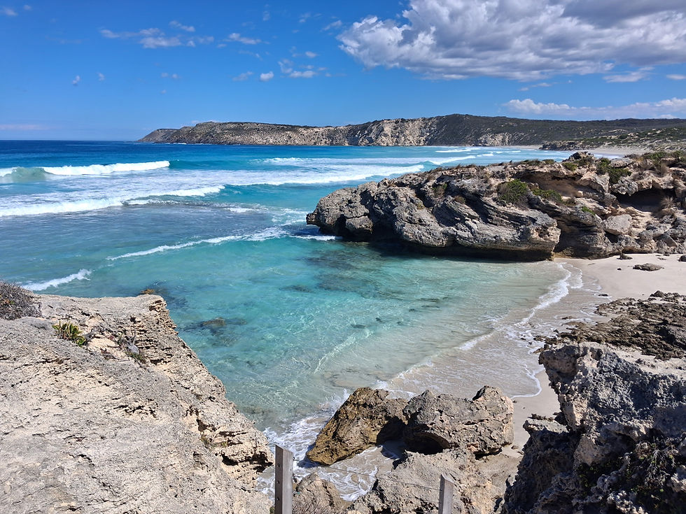
The lady who served us at the winery asked which way we were travelling and recommended a visit to Pennington Bay when we told her we were heading for Kingscote. It was well worth the short deviation to see the picturesque bay on a perfect, warm afternoon with only a gentle breeze blowing.

Next up was a visit to the Emu Ridge Distillery, where they have been processing Eucalyptus oil for decades, since the bottom fell out of the wool market. We watched a five minute video that showed the history of the distillery and the family that made it all happen before looking around the gift shop. We made a couple of purchases on the way out of eucalyptus oil and emu oil to try on Meg's insect bites that had been driving her crazy for weeks.
Then driving to Kingscote, we stopped for photos at their silo art installation before going to the campground to set up for two nights.
Day 44 - Kingscote - Kangaroo Island SA, 25 March, 2026

Today turned out completely different from what we had initially planned.
Our original intention was to walk into the town and look around at anything touristy, then have the rest of the day as a down day. However, it turned out that the campground was over 3 km away from town, and we didn't want to walk that far. Also, the previous day, we had made appointments for haircuts at 10:00 A.M. in town, which meant packing up inside Mata and driving into town for that.

We were a bit early getting into town so we checked out the jetty area and had a drive around the coast until appointment time.
We arrived at the scheduled time only to find there had been a mix up with the appointment time and we had to wander around town for half an hour while waiting. We visited a couple of shops and a really good art gallery that had loads of local works of all descriptions.
After the haircuts we thought we might as well do some exploring, going first out to North Cape, which wasn't very interesting because there was farmland between the parking area and the sea, so we couldn't see what the coast looked like.

Our next stop, which we'd planned to do the next day, was the Emu Bay Lavender Farm, where we had a look around and bought a few items.
It was only about 3 km to Emu Bay itself, so we drove there mostly just to say we'd been there, and took a photo.
Driving back into Kingscote, we stopped on the outskirts of town to have lunch and beer tastings at the KI Brewery. The beers were ok, but not nice enough for us to buy any takeaway, but the pizza we had for lunch was excellent.
Back at camp we did a load of washing and relaxed for the rest of the day.
Day 45 - Kingscote - Karratta, Kangaroo Island SA, 26 March, 2026

For our big ticket item today we'd booked lunch at The Fig Tree dining experience for midday.
Because that was hours away, we weren't in a hurry to leave camp, and found some things to do while driving to Fig Tree.
The first drive for the day was to Stokes Bay on the north-west coast of the island. To get to the beach we had to go through a narrow cave-like track, ducking right down in places to avoid banging our heads on the rocks.

The walk through the rocks was well worth it though because at the other end was a beautiful, fairly sheltered, white sand beach. There were a bunch of schoolkids on the beach and in the water, seemingly on a school excursion. We had a relaxing walk along the beach before returning to the cave track and the car park.
It was still too early to go to The Fig Tree, so we chose a lookout to drive to, to kill some more time. After suffering along rough unsealed roads for a while we discovered to access the lookout required going through private farm properties and the gate was locked. So much for that idea.

It was getting closer to lunchtime by then so we drove to The Fig Tree and rugged up in warmer clothes, because the day was quite cool, and to cover as much skin as possible because we'd been warned that there could be mozzies around.
The Fig Tree dining experience is truly unique in that the dining setting is outside, under the branches of huge fig trees, with enough foliage to keep the light rain off us that fell a couple of times during lunch.
Information for guests given to us prior to arrival said to allow three hours for the 11-course meal, and it was close to that by the time we finished.

The lone waiter was serving twelve guests, so it was some time before we received our first course and drinks. The wait was worth it though because that first course, and the following courses, were excellent, all using local produce.
By the time we got to the last main course, we were pretty well stuffed and only just managed to finish the dessert course.
To finish off the day we had a 55 km drive to the Karratta campground, stopping in at the Flinders Chase NP information centre just before the camp to get some information for exploring the park the next day. At one part during that drive we had to stop suddenly to allow an Echidna to cross the road in front of us.
It was still cool and very windy so we hunkered down inside to finish off the day.
Day 46 - Flinders NP, Kangaroo Island SA, 27 March, 2026

Today was going to be all about exploring Flinders Chase National Park, in the south west corner of Kangaroo Island, and beyond.
The cool weather that had us rugged up the day before continued throughout the day, with strong winds and cool temperatures persisting throughout the day. But this time we were well prepared, starting out the day in warmer clothes.
Setting out from camp we drove into the national park and down to the south-west corner of the park to Admirals Arch.

As with most tourist areas we'd encountered in SA similar to this, the infrastructure was excellent, with well designed and constructed boardwalks to convey us down to the arch viewing area.
Along the way we caught our first glimpses of fur seals basking on rocks away from the sea breeze. Admirals Arch itself was impressive, having been carved out by the elements over millennia.
A little further around the coast, our next stop was at the Remarkable Rocks. From a distance the rocks seemed a little ordinary but, up close, they were very impressive, also having been carved out by the elements over millennia. We were lucky enough to be the only ones there, so we took our time wandering the rocks and admiring the wild coastline.
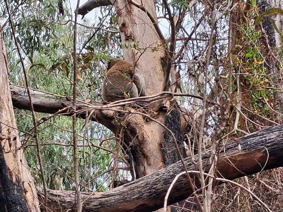
Our next adventure was walking the 2 km Heritage Trail at Rocky River, through bushland, to do a bit of Koala spotting. We (actually Meg did all the spotting) were lucky enough to spot five Koalas and a Wallaby feeding a couple of metres from us.
After all that walking and fresh sea air we were hungry, so our next destination was Vivonne, that was purported to have amazing KI Whiting burgers at the general store cafe. Not being a real fan of burgers, or of fish in burgers, I wasn't really looking forward to it that much. So, I was pleasantly surprised when the burger came out in a long toasted sourdough bun with a perfectly cooked piece of KI Whiting and salad vegetables to accompany the fish. It went down well!

The last thing we wanted to do for the day's touristing was to visit Seal Bay to see the Seal Lions, which was where we drove to next. Once again the infrastructure there was excellent, with a great boardwalk to take us down to the Sea Lion viewing area. We started to see Sea Lions well before the beach, as they were basking high up in the sand dunes, well away from the water.
Down at the viewing area we could see young Sea Lions frollicking in the surf, young and old lying right along the beach, and some hiding behind rocks, probably to escape the cold wind.
To end the day we had a 50 km drive back to the campground, where we were forced to stay inside by the cool wind and temperature.
Day 47 - Kangaroo Island - Deep Creek NP SA, 28 March, 2026

Today's primary mission was to drive back to Penneshaw to catch the 10:30 A.M. ferry back to the mainland.
With a 155 km drive to get to Penneshaw we needed to be on the road earlier than we normally would be, which can be difficult when the sun doesn't make an appearance until after 7:00 A.M.
We started off cruising at 80 km/h, still trying to conserve fuel as much as possible, but partway through the journey we realised going at that speed would be cutting it too fine, so we had to increase the speed up to 90 km/h.

We made it to the ferry terminal with a little time to spare, were directed where to park, and Meg went to check us in.
The journey over to KI earlier in the week had been extremely calm, but the return journey had the ferry rocking around enough to make us feel uncomfortable, so we mostly had to sit staring at the horizon or the mainland so that feeling didn't get any worse.
We made it back to the mainland about an hour later without losing our breakfast, then drove about 20 km to our camp for the night at Tapanappa campground in the Deep Creek NP.
After setting up and having lunch we went for a walk 1.5 further along the campground road to the Tapanappa Lookout, where there was a large group of powered model plane enthusiasts doing their thing.

The views along the coast and out to sea were beautiful, with the colour of the water varying from brilliant light greens to dark blues.
There was a loop walk around the lookout that had story boards telling the Aboriginal story of some people who stole fire from another person. Spoiler Alert! It ended badly for most people concerned.
There was a front of rain moving towards us over the ocean, so we hightailed it back to camp before it hit us.
With the rain and still cool temperatures, we hid away in our little house for the afternoon.
Day 48 - Deep Creek NP - Goolwa SA, 29 March, 2026

After a 50 km drive this morning we arrived in Victor Harbor to explore what the town had to offer.
Our first job for the morning was to fill Mata up with diesel, which turned out to be a painful experience with the price of diesel at $3.20 per litre, and which cost us $337!
We had a bit of a drive around to orient ourselves, then found a 3-hour carpark.
We were going to get the Clydesdale horse-drawn tram out the causeway to Granite Island, but decided to walk the 650 metres out there and get the tram back.

On the island there is a 1.5 km loop walk that goes right around the island, so we set out on that. The views around the bay and out to sea were very picturesque and there were some interesting rock formations scattered around the island. There are Little Penguins that frequent the island, but we didn't get to see any.
At the end of the loop walk we were just in time to get the horse-drawn tram back to Victor Harbor.

We wanted to also do an historic train ride later, which runs from the harbor to Goolwa, a thirty minute ride, so we parked up near the train station and went to check the timetable.
The next train was at 1:30 P.M., which left us with a couple of hours to kill. We managed to do that quite well by having a nice lunch and couple of drinks at the nearby Anchorage Hotel.
Still with a bit of time to spare we wandered around looking at the old buildings and visited the information centre.
Back at the station we bought tickets and had a poke around the museum while waiting for the departure time.

While we didn't get the full on steam locomotive experience the old carriages were in very good condition. For the outward journey to Goolwa we travelled in what would have been a first class carriage, all wood and leather and sash windows. Much of the trip ran along the coastline, with only the one stop at Port Elliot.
At Goolwa we had about 45 minutes before the return journey, so we had a look around the wharf area then had a beer at a German brewery bar to use up some time.
For the trip back we chose a different carriage, which turned out to be the one that Charles and Diana had travelled in when they visited the area in the 1980s.
Once back, we only had a short drive, nearly back to Goolwa, to the Crabtree Farm campground where we'd booked in for one night.
Day 49 - Goolwa - Callington SA, 30 March, 2026

Our big ticket tourist item today was a Spirit of Coorong cruise from the Goolwa boat harbour out to the mouth of the Murray River, departing at 10:30 A.M.
That gave us a leisurely start to the day, before we set out to fill in some time by visiting the town's dump point, then driving out to the Goolwa barrage on the Murray River, a little way out of town.
The 2,500 km Murray River has multiple locks, lakes, barrages (weirs) and dams. The Goolwa barrage is the last of these before the river drains into the southern ocean. It stretches across the entire width of the river.

The barrages prevent salt water from going up the river, and they also allow control of how much water flows downstream. We walked out to the middle of the barrage where there is a lock that we would be passing through later on the boat cruise.
At the boat harbour we had a 30-minute wait before boarding the Spirit of the Coorong, where we chose to sit upstairs at the front of the boat for a great view all around us.

The 90-minute cruise started out slowly on the super calm water, as the skipper gave us some background on the Murray River changing from fresh water into an estuarine area once past the barrage. At the barrage the six-metre wide lock was only just wide enough for the 5.8 custom-made boat. It was the first time either of us had been through a lock. While traversing the lock we had the bonus of Long-Nosed Fur Seals swimming around and basking in the sun on the lock lead-in timber bracing.

After the lock we drifted down the river alongside Hindmarsh Island, looking at all the expensive houses, all with jetties or pontoons.
The whole area was teeming with birdlife including Pelicans, Swans, Egrets, Ducks, Ibis, Cormorants, migratory sea birds and many more. A keen bird spotter had recently spotted 66 species of birds in a small defined area, and thousands of individual birds.
We eventually came to the mouth of the Murray River, which was a quite narrow, and not very long, channel out to the surf beach. The channel is constantly being filled with sand, so there is a full-time dredge there working the area.

On the return journey to Goolwa we spotted more seals and species of birds.
After lunching at a bakery we did a big grocery shop to refill the fridge and cupboards that we'd been running down over a couple of weeks.
With no destination in mind we started driving towards Strathalbyn. Once there we continued on for a few kilometres to the small town of Callington where there was a cheap RV park and parked up for the night.
Payment for the camp required us to walk down to the nearby cricket club, pay the $10 fee, and have a beer while we were there.
Day 50 - Callington - Tintinara SA, 31 March, 2026

Continuing on our journey down towards the south east border of the state, our first stop today was the town of Murray Bridge. Funnily enough the Murray River does run through town, and there is a bridge that crosses the river. Can't imagine how they came up with town's name!
Our first job was to visit the dump point and to fill up with fresh water, which had become quite scarce in the past few days.
In a park running alongside the river we visited the Murray Bridge Bunyip, which was quite scary.

An information board there explained the Aboriginal story of how the Bunyip came about, basically to frighten people, particularly children, who swim alone or take more fish from the river than they need. Anybody who does these things will be taken by the Bunyip.
Then, after driving across the town's titular bridge, we stopped briefly at a lookout for photos of the bridge and adjacent railway bridge, before continuing on to Tailem Bend.

We parked near the old railway station there and took some photos of the station, an old steam train in a park, and the "Uneek Animals" display, which was a collection of quirky sculptures of Australian animals.
Heading out of town we stopped at a Murray River lookout park for morning tea, then carried on to Coonalpyn, where we pulled up to take photos of their silo art installation.
The last drive for the day was to a donation RV park in Tintinara.
Once setup and after lunch we had a wander around the small man-made Lake Indawarra then relaxed for the rest of the day.
Day 51 - Tintinara - Cockatoo Lake SA, 01 April, 2026

Rain started falling during the night and was still falling by the time we left camp.
We didn't have a firm plan for the day, but there were a few points of interest we wanted to see along the way to wherever we ended up.
Before leaving town we topped up with diesel when we discovered that the price had dropped to $2.96 per litre.
Keith was our first stop for the day to take a look at a memorial to a local motorcyclist, some wall art and a Landrover up a pole. We also took the opportunity to grab a few things from the IGA.

Moving along, we drove to the Mount Monster (more like a pimple than a mountain if you ask me) Conservation Park to do the walk up to the trig station lookout. It was only a short walk but very steep and rocky, but we made it ok to the top. We were then able to walk down another track back to the carpark that wasn't so steep.
Because it was still too early to stop for the day Meg started to look for some wineries that were open for tastings. Despite driving past thousands of hectares of vineyards, and searching relentlessly for anyone doing tastings, we came up blank and had to give up on that idea. It seems that while the Limestone Coast has countless vineyards, most seem to supply the big wine makers, like Penfolds, rather than providing cellar door experiences for passersby.

Looking for an open winery took us through Padthaway, where we stopped briefly to look at a sculpture in a park that represented the industry in the area.
Another short drive took us to Cockatoo Lake campground near Lochaber, where we chose a nice grassy spot to park up on for the night.
After lunch we wandered down towards the nearly dry lake, but not so close as to scare away the myriad birdlife gathered there. We spotted a couple of White Spoonbills and two Black Swans, but couldn't identify most of the other birds, which seemed to be mostly several varieties of ducks.
Day 52 - Cockatoo Lake - Coonawarra Bush Camp SA, 02 April, 2026

With another easy driving day in front of us we weren't in a hurry to break camp this morning.
Also, the temperature was quite cool and a heavy fog had come down overnight, so visibility wasn't great.
The first town we stopped at was Naracoorte to go to the dump point and take some photos of their wall art.
Not too far out of town, we came to the Naracoorte Caves where we first went to the visitor centre. There are some great displays there of megafauna and other animals that once roamed the area, and a great walk-through diorama showing how the animals lived and interacted with each other back in the day, especially around the caves.

We chose a self-guided tour of one of the caves, the Stick-Tomato cave. It was quite impressive, but nowhere near as impressive as others we'd been to.
Our next drive was to the Bool Lagoon Game Reserve Conservation Park in the hope of seeing some birdlife that would normally reside there. Unfortunately the lagoon was bone dry, which meant there were no birds to be seen anywhere. We parked up and had lunch there.
Then, driving the backroads towards Coonawarra, we stopped off at the Father Woods Park, which was a memorial to a priest who worked in the area in the late 1800s-early 1900s, and who would stop off near this park any time he was passing through. There were half a dozen chainsaw-carved wooden statues depicting the father and others, and a lot of information boards detailing his time in the region. Father Woods and Saint Mary of the Cross McKillop were best buds back in the day.

Having missed out on wine tasting the day before in the Padthaway wine region, we decided to have another go now that we were in the Coonawarra wine region, and found a great sounding place, the Bellwether Winery.
The winery is housed in a converted shearing shed that was constructed in 1864, and it was a wonderful old building, bustling with character.
We tried five wines each, then bought a couple of bottles of our favourites on the way out.
From there it was only a short drive to the Coonawarra Bush campground, where we paid for an unpowered site for the night.
Day 53 - Coonawarra Bush Camp - Mingbool SA, 03 April, 2026

Our big ticket item for today, Easter Friday, was a wine tasting and charcuterie board lunch at the Patrick Winery in Penola.
Because the lunch booking wasn't until 11:30 A.M. we hung around the campground as long as possible, then drove into Penola to see what it had to offer.
At the information centre we got a brochure for a self-guided tour around the town that mostly focused on historic buildings. Petticoat Lane was where the oldest and most impressive buildings were, so we started there. The old houses dated from the 1850s to 1860s, and had mostly stood the test of time. Some are still privately owned and some have been repurposed like one that is now a B&B.

After driving past a few more historic buildings we drove out to Patrick Winery to indulge in some wine tasting before lunch, so we would know which wine to have with the lunch that includes a glass of wine each.
They had a full range of sparkling, whites and reds and the free wine tasting didn't seem to have any limits on how many wines you could try. We both tried the sparkling and rosé, then diverted off onto our preferred white wines for Meg and red wines for me.
Lunch came out when we'd exhausted our tastings, and we chose a glass of our favourite wine each to accompany the food, which was all local produce and tasted excellent.
After buying some bottles on the way out, we drove to our Easter getaway at the Bush Haven Cottages campsite in Mingbool, and settled in for three nights, hiding away from holidaying families at the start of the school holidays.
Day 54-55 - Mingbool SA, 04 - 05 April, 2026

Over the Easter weekend we just wanted to stay away from crowds and to have some downtime, after travelling most days for the last nearly two months.
We chose the Bush Haven Cottages campsite because it looked like somewhere that wouldn't attract families, and we struck it lucky to be the only ones in the camping area for the weekend. There were a couple of families staying in the cottages, but they were far enough away not to bother us.
We had a nice grassy site under the trees, and plugged into the 240V so we wouldn't have to worry about our power levels.
We did some cleaning around Mata, and went for a walk both days, but mostly took the opportunity to relax before starting to head north east towards Victoria.
Day 56 - Mingbool - Casterton VIC, 06 April, 2026

This was to be our last day of exploring South Australia.
Light rain started falling during the night and continued on into the morning, so we woke to a dreary morning.
After packing up from our three-night stay, we drove the 20 km into Mount Gambier.
First up was to work our way through a list of chores, which entailed filling up with diesel, emptying the toilet cassette, doing a grocery shop and filling up with fresh water.
Then on to some touristing, where our first stop was the Blue Lake, one of a few in the area. The lake, created thousands of years ago, was indeed a very deep blue colour, and very impressive.

Our next stop was the Umpherston Sinkhole, which had been created by volcanic events, and which had been planted out by the family who built a house nearby, the Umpherstons. After walking around the top of the sinkhole, we walked down steep steps to the bottom of the sinkhole and wandered around the gardens until the Easter Monday holidaymakers became too much for us.
We decided we'd had enough of crowds so we headed out of town towards the Victorian border.
There was a conservation park about 35 out of town that looked promising for an overnight stay and that was where we drove to next, which took us across the border into Victoria.

Once there though we didn't really like the place, so we parked up to have lunch before continuing on for another short drive to Casterton.
At the CMCA caravan park we got setup for a night, then went for a walk into town to visit the information centre that doubles as the Kelpie Centre.
The Kelpie Centre has a separate area dedicated to the history, and information about, Kelpie dogs, that were first bred near the town by an Irish immigrant, Jack Gleeson, in the 1870s. Although we had some idea about how Kelpies came about, it was good to read all the information to be able to separate fact from fiction.
Then it was back to the caravan park to finish off the day.


Comments